
Great driving roads
We consider ourselves to be driving guys as much as we are car guys. While we love cars (do we ever), we probably love driving them even more. Our experience tells us that while most driving guys (and gals) tend to be car guys, the inverse is often far from true (though there’s nothing wrong with that, either— we all get something different out of being car enthusiasts).

It was in that spirit that one of our earliest posts inspired us to compile and catalog all the great driving roads we hope to do one day in the contiguous 48 United States North America— something we had always kept notes on here and there, but never attempted to piece together in anything approaching a somewhat cohesive manner. This will be an ongoing exercise— as new roads that are worthy of being added to the list come to light, we will continue to update this space. If you’d like to weigh in on any of the selections or have one of your own that you’d like to share, hit us up in the comments.
Oh, and if you’d like to find other people in your area with whom to check out some of these roads, sign up for the Motoring Con Brio Google Group or find other readers of this blog on Facebook.
Happy motoring.
Jump to a section:
- The Northeast
- The Southeast and Mid-Atlantic
- The Southwest and California
- Everywhere else: the Northwest, Southeast, and Canada’s Great White North
—
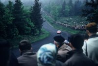
Mount Washington Auto Road – a 7.6 mi (12.2 km) toll road that extends from New Hampshire Route 16 in Pinkham Notch to the summit of Mount Washington in the White Mountains of the U.S. state of New Hampshire. The road climbs 4,618 ft (1,408 m) from an altitude of 1,527 ft (465 m) at the bottom to 6,145 ft (1,873 m) at the top, an average gradient of 11.6%.

Watch (1).
Watch (2).
—
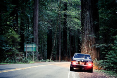
Kancamagus Highway (Woodsville, NH to Conway, NH) – a nice mix of twisties and sweeping turns with great scenery and plenty of overlooks to pull over for breaks or pictures..

—
Pennsylvania State Route 44 (from Coudersport, PA to Jersey Shore, PA) – 60+ miles without even one stop sign and almost no driveways or intersections to speak-of… Much of this route is in total seclusion – surrounded by nothing but trees and wildlife… No traffic whatsoever… A very nice mix of incredible, ever changing scenery and varying road conditions – it’s never boring.
No disagreement— we really appreciated the lack of driveways and intersections, a rare thing in the densely-populated northeastern United States. The road goes on seemingly forever— whoever called this “the best value road in PA” tells no lie. Road surface quality varies from good to great. Lots of corkscrews and blind uphill, downhill, and midcorner crests, so you really need to stay on your toes and can’t drive it too fast. We preferred – greatly preferred, even – driving it south from Coudersport, as opposed to north from Jersey Shore. Worth a repeat visit— Ed.

—
Pennsylvania State Route 125 – One of the best motorcycle or sports car roads in PA! PERIOD. Huge amounts of twisties, many 180 degree banked turns, blind curves, hill climbs, etc… This road is, in two words, ‘driver’s paradise’… This road is simply the best twisty road within two and one half hours drive of New York City. Bar none… the ‘Tail of the Dragon’ of the northeast…
The combination of Gold Mine road and PA 125 is very much like a roller-coaster ride, with a series of very steep climbs and descents with sharp corners at the top and the bottom, with a few rolling hills and gentle corners mixed-in for good measure…
A road in Pennsylvania coal country that’s equal turns challenging and entertaining, smooth-as-a-baby’s-bottom and hang-onto-your-hat-bumpy (the detour onto PA-25 mid-route, in particular), hilly country road and winding mountain road, but unfortunately dotted with homes and small villages at various points of the route, which, as spirited driving enthusiasts, we don’t exactly love. If you like hairpin turns, 125’s got ’em in spades. Its proximity to NYC is also a major selling point— Ed.

(Go back to the top.)
—
The Southeast and Mid-Atlantic
Blue Ridge Parkway – An American treasure. Mind-boggling in its length (469 miles end to end, of which we ended up driving 350), and not quite an uninterrupted stretch of driving enjoyment (you will at times encounter any combination of long straight sections (watch your speed there), slow vehicles, bicyclists, road closures, and lots and lots of fog), we nevertheless couldn’t think of a better interstate (with a small ‘i’) road to take while traveling anywhere between central Virginia and the Great Smoky Mountains of North Carolina. The stunning panoramic vistas along the way are icing on the cake— this is *the* way to experience the majesty of the southeastern United States. You will arrive at your final destination later than if you were to take the Interstate system proper, but the Blue Ridge couldn’t be more of a welcome alternative to the mind-numbing monotony of the latter— Ed.

—
Little Parkway (US 221 from Blowing Rock, NC to Grandfather Mountain (Linville, NC) – Arguably the prettiest road we drove – tree branches hang low to form a shady canopy over the road for much of its length – but with lots and lots of flowing corners, it’s not just for Sunday drivers (though you will encounter them also). The main challenge you will face is keeping your eyes on the road when you’ll want to be craning your neck to take in the incredibly lush surroundings— Ed.

—
The Diamondback (North Carolina 226A from Spruce Pine, NC to Marion, NC) – A steep ascent. Tight 2nd gear turns. Sheer drop-offs. No guard rails. The occasional driveway dotting the road. The Diamondback is a white-knuckle ride, possibly the most thrilling of the bunch, and that’s why we loved it enough to do twice: once on an out-of-the-way but ultimately worthwhile detour en route to the Dragon, and again on the return home. Not the prettiest drive, but that’s not why you’re there— you are there to stretch your car and yourself as a driver. And in that regard, the Diamondback delivers. Big— Ed.

—
Devil’s Staircase (NC 80 from Micaville, NC to Lake Tahoma, NC) – The sleeper of the bunch. We stumbled onto this one purely by accident, and what a happy accident it was. Comparable in grade to the Diamondback – that is to say, steep – but with prettier views and corners that flow a little better by virtue of not being quite as tight. If all we could ever drive for the rest of our days was this road, we’d be happy— a testament to just how good it is— Ed.

—
Tail of the Dragon – the grandaddy of them all. The main event. Some – okay, many – will say that the Tail has gotten too big, too popular. That the secret has been let out ages ago, consequently letting in innumerable car and motorcycle clubs, the Harley Davidson crowd, flatfooted thrillseekers, and local law enforcement officers. They wouldn’t be incorrect, but during our time there we really did feel there was nothing quite like the Dragon. So many banked 2nd gear switchback turns coming at you in an endless barrage, one right after the other. It’s a real workout, for car and for driver. The whole thing feels like a rollercoaster. And there are no intersections. For tight, technical driving this one is really hard to beat— Ed.

—
Hellbender 28 (North Carolina 28 from Stecoah, NC to Tapoco, NC) – The warm-up to the Tail of the Dragon— and what a heck of an appetizer it is. Not as tight and technical as the signature attraction that it precedes, but plenty entertaining in its own right. So good that it initially threw us for a loop— we thought we had stumbled onto the Tail before realizing we hadn’t reached it yet. Hugs Cheoah Lake for a short, scenic stretch. There are occasional intersections and driveways along the way (for things like lodging and campgrounds), but they are relatively far between and few— Ed.

—
Cherohala Skyway (Tellico Plains, TN to Robbinsville, NC) – Combines with Moonshiner and the Tail to form a lovely, varied driving loop. This is the longest of the three (stretching 43 miles) and also the fastest— there are some tight turns here as well, but this road is more about fast, sweeping corners. Virtually no intersections to speak of, though it can get foggy as you approach its peak elevation of one mile. Provided you don’t get caught behind slow-moving traffic, the Skyway ought to provide you with long, uninterrupted stretches of quality back roads driving— Ed.

—
Tennessee State Route 52 – If you’re not too scared by the prospect of having a breakdown in the town of Red Boiling Springs, you’ll find this drive one of the more exhilarating (and exhausting) in the eastern half of the country. Chances are you’ll have the road to yourself, so be careful not to plant your car into one of the sheer rock faces that serve as guardrails along many of the off-camber, 20-mph turns. This is a road where you pack light, strap everything down, and focus on the task at hand. By the time you’ve made it to I-75 you’ll be sweating and ready for a break.

—
West Virginia State Route 15 – West Virginia claims to be “almost heaven,” and a day of driving its less beaten paths will likely confirm that claim. Countless small state roads follow the ridges of the Appalachian Mountains, providing spectacular views and mile after mile of twisty roads. State Road 15 is one such route. The 65-mile drive between Interstate 79 and US 219 will take the better part of of two hours, more if you stop to take in the beauty.
Though nominally one route, WV-15 can actually be broken out into three or more sections, each a great drive in its own right.
Valley Head to Webster Springs is classic mountain pass driving with a little bit of everything: climbing switchbacks, straights, and sweepers. Medium to fast corners. Variable road quality, but mostly good to great. Some homes lower down the mountain, which thin out as you climb toward the peak.
Webster Springs to Diana is more mountain pass driving, albeit relatively shorter at ten or so miles. More homes and residences here, but traffic (cars and people) isn’t bad and there are still almost no stops or intersections to speak of. Road surface quality here is iffier, but still eminently drivable (nothing as bad as in the Northeast). A fun little section.
Diana to Sutton is lower elevation driving, but still features plenty of hilly and winding country roads. Nice road quality, fast corners, as well as some decreasing radius turns. There are homes near Diana and more as you start to approach Sutton, but the middle section is a real peach. The section that approaches Sutton is probably the least interesting because at that point it starts to get pretty residential. Just turn around and do it again in the opposite direction.
In aggregate, probably one of the single finest stretches of uninterrupted driving road that we have come across to date, if not the finest— Ed.

—
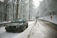
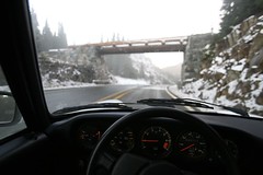
US Route 250 from Churchville, VA to Huttonsville, WV – some of the most challenging and exhilarating public driving roads we have ever encountered! Steep elevation climbs, tight switchbacks and banked corners, slow hairpin turns— they’re all here, along with some straights and some sweepers thrown in for good measure. In general, this isn’t fast corner country. Driving it in the winter can be precarious. Exercise extreme caution and make sure you have snow tires— otherwise, skip it.
The road keeps going from Huttonsville on to Moundsville which we have not sampled as of the time of this writing— Ed.

—
Wolf Pen Gap/Blood Mountain – This is a great ride through Wolf Pen Gap, up Blood Mountain and past the Two Wheels Only motorcycle resort in Suches, Georgia. Beside the Dragon, I doubt you can find a more challenging ride in the Appalachians.

(Go back to the top.)
—
Twisted Sisters (Texas Hill Country) – Wonderful, beautiful ride! Twisties, switchbacks, rivers, beautiful scenery, and yes, it’s like being in the mountains in Texas… This rivals some of the Arkansas roads..

—
US Route 191 from Morenci, AZ to Alpine, AZ – what sets this one apart is the distance (90 miles) and seclusion. I have done the whole drive and not seen a single car on the road. We caught up to 3 trucks this time, probably because its prime hunting season. The corners are almost too tight in some sections, a lot of first gear if you want to stay in the powerband…
They say there are 427 curves on AZ Road 191 between Clifton and Alpine. The road also has some breathtaking ascents along the way that will keep your engine revving. The most dramatic elevation changes are near the town of Morenci, AZ. In fact, the speed of traffic will slow down to just 10 MPH at certain points…

—
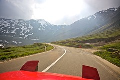
Pikes Peak Highway – a 19-mile (31 km) toll road that runs from Cascade, Colorado to the summit house of Pikes Peak in El Paso County, Colorado.. The road is maintained by the city of Colorado Springs. The bottom third of this road is paved while the upper portion is gravel.

—
Loveland Pass – elevation 11,990 ft (3,650 m). (3655 m) above sea level, is a high mountain pass in the Rocky Mountains of central Colorado, U.S.A.. It is located on the Continental Divide in the Front Range west of Denver. U.S. Route 6 traverses the pass; the twisty road is considered to be especially treacherous during the winter months. A steep, steady 6.7% grade, along with numerous hairpin turns on either side, make it difficult to snowplow the road regularly. Loveland is the highest mountain pass in the world that regularly stays open during a snowy winter season.

—
Independence Pass – el. 3686 m./12,095 ft., is a high mountain pass in the Rocky Mountains of central Colorado in the United States. The approach on either side is a steady but steep 6.5%. Several switchbacks on each side of the pass make careful planning a must. The pass is always closed in winter, from the first heavy snow fall in autumn, often opening only in late May.

—
San Juan Skyway – our nod for the best driving road in [Colorado] goes to the San Juan Skyway, particularly the 50-mile stretch from Ouray to Silverton. We have reason to believe the pop-culture expression “Oh. My. God!” was first uttered on this road.

—
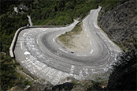
Nevada State Route 341 (the Occidental Grade from Silver City to Virginia City) – a 5.2 mile mountain road with 22 [or so] turns.. none the same. The camber of the roadway changes radically, for no rhyme or reason. From afar, some of the straight sections of roadway look like a long piece of orange Hot Wheels track, twisting back and forth. Never straight or flat. A “correct” line here means avoiding the snow markers, which are sometimes positioned right where you would want to apex a corner. And sometimes not. And they get replaced every few years with new ones that crop up in different spots. There are very few guardrails. None where you think they should be. There are no run-off areas, no tire walls, no hay bales, no berms, no nothing. The drop offs are everywhere and they are unforgiving.

—
Angeles Crest Highway – a two-lane (one lane of travel in each direction) segment of California State Route 2 in the United States. The road is 66 miles (106 km) in length, with its western terminus at the intersection at Foothill Boulevard in La Cañada Flintridge and its eastern terminus at State Route 138 northeast of Wrightwood. The majority of the route passes through the mountainous terrain located north of the Los Angeles basin. Its alignment passes through the Angeles National Forest in the San Gabriel Mountains. Segments of the road reach altitudes above 7,000 feet (2,100 m), with a summit of 7,903 feet (2,409 m) at the Dawson Saddle, which makes this road one of the highest in Southern California.
C/D: ..a writhing, mountainous, 66-mile facsimile of the Nürburgring..
Forbes: ..much of it is a two-lane road on which motorcycle and sports car drivers love to speed.. (“America’s Scariest Highways”)

—
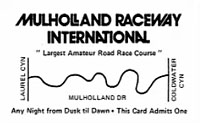
Mulholland Drive – a road in Los Angeles, California, United States, named after engineer William Mulholland. The mostly two-lane, minor arterial road loosely follows the ridgeline of the Santa Monica Mountains and the Hollywood Hills, connecting two sections of U.S. Route 101, and crossing Sepulveda Boulevard, Beverly Glen Boulevard, Coldwater Canyon, Laurel Canyon Boulevard, Nichols Canyon and Outpost. It offers views of both the Los Angeles basin and the San Fernando Valley.

Read.
—
Ortega Highway (California SR 74) – rare straight sections.. one of the best driving roads in Southern California.. snakelike undulating curves and bends..
SSL: …a road of two halves; one green and lush, full of sweepers and 60 MPH constant radius turns, and the other a rapid ascent up a canyon and down a mountainside into the high deserts of Riverside County surrounded by scrub brush and tight blind corners…

—
Little Tujunga Canyon Road (Los Angeles County Foothills) – Little Tujunga introduces itself with a sign- Curves 18 Miles. Then a few gentle weaves offer up the hors d’oeuvres for the first 5 miles riding toward the range. Elevation here is about 1100 feet (at the 210 Feeway) and will climb to about 2700 feet at the summits…

—
17-Mile Drive – a scenic road through Pacific Grove and Pebble Beach, California, United States, much of which hugs the Pacific coastline and passes famous golf courses and mansions. It also serves as the main road through the gated community of Pebble Beach. Like the community, the majority of 17-Mile Drive is owned and operated by the Pebble Beach Corporation. The 17-Mile Drive is 9.6 miles long, between the entrances at US-1 and Sunset Drive.

—
Laureles Grade – [also known as] County Route G20… is a steep, winding road running 6 miles (10 km) to connect Carmel Valley with State Route 68 halfway between Monterey and Salinas [California].

—
Carmel Valley Road – The 50-mile drive from the oceanside hamlet of Carmel-by-the-Sea [California] to the agricultural valley of Greenfield is one of the most challenging driving roads you’ll find in this great land of ours. Essentially a livestock path that cuts over the mountain range separating coast from inland, the barely-two-lane asphalt of Carmel Valley Road clings to the rocky topography for dear life. In several places, the lane narrows to a single car’s width with almost no warning, and iron cattle grates pop up mid-apex in a few corners, just to keep things interesting.

—
Stewarts Point-Skaggs Spring Rd. from Stewarts Point, CA to Warm Springs Dam, CA – known as the Holy Grail of California motorcyle roads…

—
Pacific Coast Highway – legendary, but the road between Monterey and Santa Monica is perhaps its definitive stretch. For the drive south, you’ll have the Pacific Ocean outside your right window for almost the entire drive…
1 North from Cambria to Monterey, a.k.a. the Big Sur Coast Highway, has got to be one of the best driving roads in the world, both in terms of scenery and degree of difficulty. This ridiculous ribbon of tarmac snakes along the rim of the Pacific Ocean for miles and miles, 63 of which are particularly glorious…

—
Trinity Highway (Highway 299) – [Northern California,] 100+/- miles (total) of second and third gear turns through the mountains while tracing the path of the Trinity River some four hundred feet down beside you. Steep grades straight into hairpin turns sweeping upwards to the right or left and then a quarter-mile of straight tarmac into more sweeping lefts and rights, back up another part of the mountains and on it goes. Anybody with the chance to drive this road should jump at it. Nothing to regret… Some of the best roads the country has to offer.

—
California State Route 25 (Highway 25) – one of California’s poster-child motorcycle roads… There are some very long straights on the northern portion so if you’re expecting an adrenalized canyon ride, this isn’t one of them. Just cruise along and enjoy the long straights that stretch off to the distant ridgeline, the twisties will come soon enough…
Peter Schwarzenbauer (President, Porsche Cars North America): includes a wide variety of corners, from slow hairpins to fast sweepers, a smooth road surface and scarce traffic. The perfect sports car road.

—
Sonora Pass (California State Route 108 from Sonora to Junction US 395) – the climb to Sonora pass is unbelieveable…twisties like you wouldn’t believe, but be careful, there are no warning signs and the road is hard to read… As soon as you get east of Oakdale, the terrain gets interesting. 108 is full of sweepers and hairpin turns. The road is smooth asphalt and generally clean. As you climb in elevation, the temperature drops and the views are unbelievable…

—
California State Route 33 (Highway 33 from Ventucopa to Ojai) – …a driver’s paradise. It’s a road lacking in everything you hate if you like enjoying fast cars. Highway 33 has no traffic, no driveways, no law enforcement, and often no guardrails… What it does have is curves. Lots of them.

(Go back to the top.)
—
Everywhere else: the Northwest, Southeast, and Canada’s Great White North
Beartooth Highway (Red Lodge, MT to Yanceys, WY) – another gem of a road from Tower Junction in Yellowstone to Red Lodge, Montana. Almost 100 miles of scenic views, twisty roads–a grand experience you won’t forget!

—
Dalton Highway (Alaska Route 11) to Deadhorse, AK – Not especially known to be a great drive (nor in the lower 48), but just to say that we did it. One of the most isolated roads in the United States… comes to within a few miles of the Arctic Ocean… all vehicles must take extreme precaution when driving on the road, and drive with headlights on at all times… there are quite a few steep grades (up to 12%) along the route…

—
Overseas Highway (US Route 1 from Key Largo, FL to Key West, FL) – Another, but how can you argue with this visual:

—
Ontario Highway 556 from Heyden, Ontario to Aubrey Falls, Ontario – 110 kilometers (68 mi) in length, of which only 27 km (17 mi) are paved. This paved section runs from its western terminus to its intersection with Highway 532 near Searchmont and is therefore informally known as the Searchmont Highway. From this point, the highway surface is rough gravel for its remaining length. Ranger Lake is the only community on this portion of Highway 556. Despite its relatively poor surface, it is considered an alternate link between Chapleau and Sault Ste. Marie.
Automobile Magazine: [Ranger Lake Road] (sic) is one of those roads that we all dream about: utterly deserted, free of intersections, and packed with more curves than a fitness franchise. Unfurling past frozen lakes and between impenetrable walls of snow-draped pines, its surface is normally graded dirt, but since we’re traveling in the dead of winter, there’s a layer of packed snow on top. It’s fifty-two miles of the most rally-ready roadway I’ve ever laid eyes on…

No road trip is complete without a classic meatloaf recipe meal at a quirky roadside diner. The cooks always know the right meatloaf temp to get the customers fed quickly so they can get back on the road.
(Go back to the top.)


nice compliation, I might just try to get some in this summer
Brendan said this on February 21, 2010 at 11:16 am |
[…] S2000, doing it’s thing on WV State Route 15, dubbed one of the best driving roads in the country (I agree!). And with dedicated snow tires, the drive wasn’t any less fun. […]
Road Trip! : Tom Olesnevich said this on April 14, 2010 at 9:35 pm |
I drove a van along most of the Dalton Highway in Alaska last June. The big trucks have the right of way. I got three cracks in my windshield from flying gravel, even though I pulled way over everytime a big truck came past. I thought the third rock was coming in! Whack! Nonetheless, this road is as epic as Alaska!
Zahara said this on November 8, 2010 at 10:06 pm |
of possible interest for anyone thinking of driving to maine or new hampshire:
Leigh D. on her road trip to Maine’s Acadia National Park
motoringconbrio said this on January 7, 2011 at 6:51 am |
Two other great roads in the Northeast are RT 100 in Vermont. It goes pretty much the whole length of the state and there’s beautiful scenery on a road with some nice sweepers. Around Sugarbush, it links up with RT 17. That is a very technical road that traverses two mountains. Very fun but watch out for the motorcyclists in the summer.
Also, thanks for the love in your links sidebar. We gave you a shout out in our latest post. Keep up the good work!
Danny Chin said this on January 12, 2011 at 3:28 am |
thanks for the tip on VT, as well as for the good words! certainly return the compliment.
motoringconbrio said this on January 12, 2011 at 11:11 am |
tamerlane provides this nice snapshot of the ortega hwy (sr-74) in southern california:
Hell’s Kitchen Ortega Highway Lake Elsinore
motoringconbrio said this on February 15, 2011 at 10:43 am |
check out the peak to peak highway in between Estes Park, CO and Nederland, CO. Stunning and empty for the most part. My turbo Volvo loved eating up the miles here. And the scenery is stunning, not to mention the two great towns, one on either end.
Austin Brown said this on December 1, 2011 at 5:14 pm |
thanks! i am occasionally in CO, so will be sure to check it out when i can.
motoringconbrio said this on December 1, 2011 at 5:26 pm |
If you think of it, let me know when you’re planning on being out here! I’ve got a lot more that aren’t coming to mind – for example any of the canyon roads along the front range – up is fun, but down is always a blast!
Austin Brown said this on December 1, 2011 at 6:41 pm |
sure! the truth is, there are *so* many good roads out there that it’s hard to go wrong. they are everywhere.
here’s an old trip report from the early days of the blog:
motoringconbrio said this on December 1, 2011 at 6:52 pm |
Looks like a great loop! I’m sure a car with a turbo would have been appreciated 😉 I used to drive an old Volvo 240 wagon, but I’ve upgraded to a 2004 S60 2.5T AWD and it’s amazing the difference I can feel. I’m considering taking that loop or a modified version of it this weekend if the snow melts! Next time, take a spin down Rt 6/Rt 40 (known to locals as clear creek canyon rd.) – it’s right in the middle of that circle and has some stunning scenery.
Austin Brown said this on December 1, 2011 at 7:15 pm |
really nice compilation all the more reason to drive the states than fly over them i say.
i have to nominate another route for you. Valley of Fire Highway, I actually did a post on it http://narrowlanes.net/2011/06/20/roads-valley-of-fire-hwy-part-1/
its a must do for any enthusiasts in or around vegas
Gilberto Cedolia said this on January 29, 2012 at 1:14 pm |
[…] https://motoringconbrio.com/great-driving-roads/ […]
Great Motoring Drives… | My Motorways said this on February 9, 2012 at 1:19 pm |
Palomar Mountain and Sunrise Highway between LA and San Diego have good roads, apparently:
motoringconbrio said this on December 4, 2012 at 10:24 pm |
Been up and over Palomar over a hundred times. One of my all-time favorite drives.
Once drove from Temecula to the 8, taking Rice Canyon to the 76, 76 to the south grade of Palomar, down the east grade (did that up and over about twelve times), reconnected with the 76 to Mesa Grande, Mesa Grande to the 79, 79 through Julian to the Sunrise Highway then I did it all over again. Taking the 78 out of Julian to Ocotillo can be amazingly beautiful and the downhill is tight and twisty- tests the brakes of a ’95 Range Rover Classic before some rock crawling in Fish Creek!
Couser Canyon and West Lilac Road are also unmissable if you’re in the Palomar area.
SOneThreeCoupe said this on March 29, 2013 at 5:32 pm |
NY state. RT 97 going from 84 in POrt jervis takes you along Delaware River for over an hour. Once in Hancock, jump on 17 and from there take rt 30. How far you take 30 is up to you, but the first 50 miles I can tell you are amazing.
Dave said this on December 10, 2012 at 8:52 am |
Yes! Good call. I am a big fan of 30. Hawk’s Nest ain’t bad, either 😉
Thanks for commenting!
motoringconbrio said this on December 10, 2012 at 9:47 am |
Possibly worth a look— Hwy 36 between Fortuna and Red Bluff in Northern California:
http://goo.gl/maps/kLMyE
http://www.teamshredtour.com/reno-trip-day-5-curves-the-next-140-miles/
motoringconbrio said this on December 14, 2012 at 1:02 pm |
Epic road, had it completely to my self, not many straits, just twisties. Simply amazing.
james said this on November 24, 2014 at 3:42 pm |
The Richard B. Russell Scenic Highway in GA and Highway 64 in NC are supposed to be great drives:
https://motoringconbrio.com/2013/01/08/reader-submission-richard-b-russell-scenic-highway-ga-and-highway-64-nc/
motoringconbrio said this on January 7, 2013 at 9:56 pm |
Nice compilation. Have enjoyed some roads listed, and am looking forward to trying others. Re: The Blue Ridge Parkway. It’s worth noting that the Parkway south of Ashville (the highest stretch) can be driven without seeing traffic early on Sunday mornings. It’s especially good after Labor Day in early September. Enjoy the sweepers and breathtaking views.
Ron Shelby said this on March 17, 2013 at 10:52 pm |
Is this a drive you get to do regularly, Ron? I’m certainly very envious.
motoringconbrio said this on June 18, 2013 at 12:03 am |
Meanwhile, in Ohio:
https://motoringconbrio.com/2013/06/18/ohio-who-knew
motoringconbrio said this on June 18, 2013 at 12:03 am |
Great compilation… Living in Winston Salem, NC, for the past 2 years, I had the pleasure of driving on the Blue Ridge Parkway every other month. I have also driven on 221, Devil’s whip NC80 and Diamondback 226A in my 325i bimmer. Cant wait to check out Tail of the Dragon.
Karthik said this on September 29, 2013 at 9:53 pm |
So jealous 🙂
motoringconbrio said this on September 29, 2013 at 10:13 pm |
[…] you go from Coudersport, PA to Jersey Shore, PA you’ll be driving about some of the best sports car road there is. The road is over 60 miles, […]
Best Roads in America for Driving Your Audi | Audi Mission Viejo said this on December 11, 2013 at 2:52 pm |
This is Nevada State Route 341:
motoringconbrio said this on February 3, 2014 at 11:11 pm |
Angeles Crest:
motoringconbrio said this on February 3, 2014 at 11:19 pm |
Seth in PA recommends Route 895 from Pine Grove, PA to Bowmanstown, PA:
http://www.motorcycleroads.us/roads/pa895.html
“It is a narrow stretch across Schuylkill County with numerous twists, turns, blind corners, chicanes, ups, downs and some nice flat spots for opening up. Its nothing crazy but its a good cruising spot that offers some surprises. The only bump is crossing over route 183 which can prove tricky sometimes and the occasional senior citizen who still knows the road exists. The drive should prove some nice views of the Appalachians and a breath of fresh air, nothing clears my head like a Sunday drive in the ‘stang down 895.”
motoringconbrio said this on March 4, 2014 at 10:13 am |
LA recommendations:
http://www.petrolicious.com/petrolicious-automotive-guide-to-los-angeles
motoringconbrio said this on May 28, 2014 at 11:36 pm |
For Interstate roadtrippin’ (not necessarily “driving roads” as referred to here):
http://knowmore.washingtonpost.com/2015/03/10/data-geniuses-have-figured-out-what-the-ultimate-u-s-road-trip-looks-like/
motoringconbrio said this on July 31, 2015 at 5:44 pm |
amazing list of roads to drive.. I did some of them after reading about them here and loved every single one of them. I just relocated to Northwest USA and I don not see any roads in the list. I am pretty sure with Cascades and Olympic Peninsula, there would be many but does anyone has any suggestions?
apoorv gupta said this on August 18, 2015 at 5:04 pm |
Hi apoorv,
PNWer and MCB contributor David in his piece suggests the following:
Highway 410 around Mount Rainier; some of the back roads around the Columbia River just west of Hood River, Oregon; the rolling grasslands of central Oregon and eastern Washington. British Columbia also has a lot to offer; for the past two years, I’ve done the Spring Thaw rally in BC, which is a great way to explore that area.
Good luck and please be sure to let us know what you find.
Cheers,
motoringconbrio said this on August 18, 2015 at 10:21 pm |
thanks! I might go to California.. planning to drive some of those roads listed.
apoorv gupta said this on August 21, 2015 at 3:03 pm |
There are numerous roads in Arkansas. The Arkansas dragon being the best of them on highway 123. Highway 7 and Highway 16 in Arkansas are epic as well. In far west Texas Highway 170 in the Big Bend area is one of the more under rated roads in America.
John Chaney said this on November 5, 2018 at 7:27 pm |